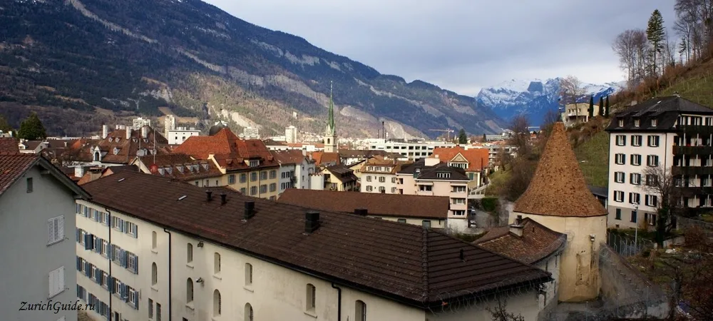
Chur
Settled for five thousand years, capital of Graubünden, and the junction where every scenic railway in the east begins.
Chur claims to be the oldest town in Switzerland, and the claim holds up: excavation under the town has found continuous settlement going back roughly five thousand years, to the neolithic. The Romans made it the capital of a province, and it has been a bishop’s seat since the fifth century.
It is the capital of Graubünden, the largest and emptiest canton, where all three of Switzerland’s language families meet — German, Italian and Romansh.
Most visitors pass through it changing trains, which is a shame, because the old town is compact, largely pedestrian, and worth two hours.
History
A fire destroyed much of the town in 1464. The craftsmen brought in from German-speaking areas to rebuild it stayed on, and where Romansh had until then been the town’s everyday language, German began to share the streets with it — the two have coexisted in Chur ever since.
The old town
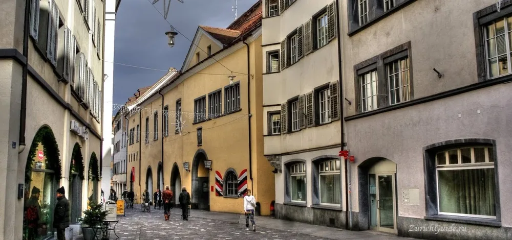
Small enough to see properly in a morning, with painted house fronts, arcades and two surviving town gates.
Most of what stands today was rebuilt after that fire, and dates from the sixteenth century; only the cathedral and a handful of medieval towers around the old wall line — including the two surviving gates — are older.
The Hof — the cathedral quarter — sits slightly above the rest and was a separate walled enclave belonging to the bishop, which is why it feels detached. The cathedral of St. Mary of the Assumption is twelfth-century, dark, and holds a late-Gothic carved high altar that is among the largest in the country. The treasury has reliquaries going back to the Carolingians.
The Hof was a fortified precinct of its own, walled separately from the rest of the town, with the bishop’s castle standing inside alongside the cathedral. Towers and stretches of that wall survive around the cathedral today, and the hill gives a wide view over the old town roofs to the mountains beyond.
A diocese existed here by the fourth century; its first recorded bishop dates from 451, and a first cathedral is thought to have gone up around 450. The present building went up between 1150 and 1272, as a Romanesque basilica, and a Baroque-style domed tower was added in 1600. The high altar, one of seven in the church, was carved by Jakob Russ in 1486–92 and includes a large triptych; the stained-glass window above the west door dates from the late nineteenth century, and the vaulted ceiling of the Chapel of St. Lawrence from 1467. In 1993 the cathedral was robbed and several altar paintings taken; the stolen works were recovered four years later.
Rathaus
The town hall, on Poststrasse, is a two-storey yellow building with shutters painted in Chur’s black, white and red. It was built in the second half of the fifteenth century; inside are a courtyard and a set of finely decorated rooms, among them the Ratssaal, and a sizeable mineral collection open to visitors.
St. Martinskirche
One of the largest Protestant churches in Graubünden, and its Gothic tower — visible over the rooftops from most of the old town — is the easiest landmark to steer by. Inside, three stained-glass windows depicting the Nativity were made in 1919 by Augusto Giacometti, whose work also hangs in the Bündner Kunstmuseum.
Kornplatz
A pedestrian square south of the post office, at the centre of the old town. It was called Klosterplatz until 1672, after the Convent of St. Nicholas that once stood just to the north; when the convent was dissolved and a grainstore built on the site, the square took the name Kornplatz — Korn is German for grain. The convent’s side chapels and church were pulled down in 1827–28 to make way for an administrative building on the square’s north side, which still stands. The grainstore itself moved elsewhere in 1840, but the name never changed. One house on the square carries murals painted by Alois Carigiet in 1955.
The town gates and walls
Two gates and a scatter of towers are what is left of the medieval fortifications. Obertor, by the Plessur river, was the main way into the walled town, and a food market sets up behind it on Saturdays. Maltesertor, on the corner of Grabenstrasse and Engadinstrasse, is the other surviving gate; gunpowder and munitions were once stored inside it. A third tower, the Sennhofturm, also survives, though it is now part of the town prison and not open to visitors.
A short way from St. Martin’s church, on the way up to the Hof, stands the Antistitium, a listed four-storey house with a Gothic-arched doorway and a hipped roof. It belonged to the monastery of Disentis until the Reformation, after which it became the official residence of Chur’s senior priest; it was one of the few old-town buildings to survive a later fire, and its decorated ceilings are worth a look.
Bündner Kunstmuseum holds Giovanni Segantini, Angelika Kauffmann and the Giacomettis — Alberto’s family came from the Bergell valley in this canton. The building’s 2016 extension is a dark cube of patterned concrete and is worth seeing on its own.
The top floor is largely devoted to Graubünden’s own painters, among them Augusto Giacometti — a cousin of the family that produced Alberto — whose 1919 stained-glass windows also hang in St. Martin’s church nearby. Angelika Kauffmann (1741–1807), born in Chur, has a room of her own downstairs, and later Graubünden artists on show include Lenz Klotz and H. R. Giger.
Rätisches Museum covers five thousand years of the valley in a townhouse.
The collection runs from Roman-era coins, weapons, armour and everyday objects to Alpine farming tools, alongside religious paintings and reliquaries once kept in the cathedral crypt.
Finding your way
Coming from the station, the old town lies to the left if you arrive from Zurich. Bahnhofstrasse runs into Postgasse, which cuts through the old town and leads to St. Martin’s church — its tower is visible from most of the approach. Both streets carry most of the shops, from department stores such as Manor and Globus down to smaller, mostly mid-range outlets; the oldest core of the town is a little further on, around Obertgasse, Untere Gasse and Arcas. Postal buses leave from the upper concourse of the station, up the stairs from the main hall.
The railway junction
This is why most people are here, and it is a good reason.
Chur is where the standard-gauge national network meets the Rhaetian Railway, the metre-gauge system that covers Graubünden. From this station:
- The Glacier Express west towards Zermatt, and the Albula line south-east to St. Moritz — both UNESCO-listed
- The Bernina Express south to Tirano in Italy
- Lines into the Prättigau, the Surselva and towards Davos and Arosa
The Arosa line deserves a mention of its own: it leaves Chur through the streets, running along the road past the shops before starting a 1,100 m climb into the mountains. It is an ordinary local service and one of the best hours of railway in the country.
Postal buses fan out from Chur across the rest of Graubünden and into Ticino, mostly from the same upper concourse as the trains. For a stay based here, the regional graubündenPASS is worth knowing about: it covers unlimited travel on the Rhaetian Railway and most local buses within the canton, plus discounts on some mountain railways — see tickets and passes.
Nearby
- The Rhine gorge — the Ruinaulta, half an hour west, white limestone walls above the young Rhine, best seen from the train or by raft
- Arosa — an hour up the valley, ski resort in winter, walking in summer
- St. Moritz — two hours on the Albula line
- Bad Ragaz — twenty minutes north, for the thermal baths and the Tamina gorge
- Landquart — an outlet shopping village
- Brambrüesch — cable car directly above the town, up to around 1,600 m; ski slopes for beginners in winter, walking paths the rest of the year
Getting there
- By train — Zurich an hour and a quarter direct.
- On foot — the old town starts five minutes from the station.
When to go
Any time; it is a working town rather than a resort. Autumn is the pick, when the Graubünden larches turn and the light in the valley is at its best.
Where to park in Chur
| Car park | Spaces | Fee | From centre |
|---|---|---|---|
| Underground car park | — | paid | 190 m |
| Underground car park | — | paid | 200 m |
| Parkhaus Bahnhofplatz underground | — | paid | 360 m |
| Stadtbaumgarten underground | 350 | paid | 450 m |
| Underground car park | — | paid | 530 m |
| City underground | — | paid | 560 m |
| Underground car park | — | paid | 710 m |
| Calandapark underground | — | paid | 1.4 km |
2 more are mapped nearby — see them on OpenStreetMap.
Data © OpenStreetMap contributors, ODbL licence, snapshot of 22 August 2026. The map is drawn by volunteers: the list is not complete, and a dash means “not recorded” — not “free” and not “no spaces”. This is not an official parking directory: when you get there, read the signs and the machine at the entrance.
Weather in Chur month by month
| Month | Day | Night | Rainfall |
|---|---|---|---|
| January | +5° | -2° | 54 mm |
| February | +7° | -2° | 40 mm |
| March | +12° | +2° | 53 mm |
| April | +16° | +5° | 50 mm |
| May | +20° | +9° | 70 mm |
| June | +23° | +12° | 93 mm |
| July | +25° | +14° | 101 mm |
| August | +25° | +14° | 119 mm |
| September | +20° | +10° | 77 mm |
| October | +16° | +7° | 67 mm |
| November | +10° | +2° | 69 mm |
| December | +6° | -1° | 58 mm |
Normals for 1991–2020 from MeteoSwiss, station Chur, open data, version of 29 July 2026. Day and night are the average daily high and low, not records; rainfall is approximate. Current conditions from the Norwegian Meteorological Institute, CC BY 4.0.
Updated: